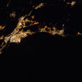
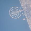
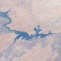
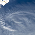
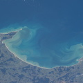
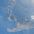
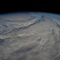
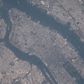
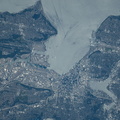
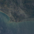
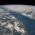
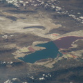
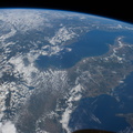
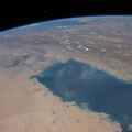
 visible from the top of the ISS orbit (approximately 52 degrees north), the highest latitude flown over by the spacecraft. In fact these linear zones are gentle folds in the surface rocks of the area, lying slightly lower than the surrounding lighter-toned agricultural lands. The dark zones are forested with pines and dotted with salt-rich lakes. The image width (left to right edge) represents more than 300 kilometers ground distance, and the forested spikes are nearly that length. The green floodplain of the famous Ob River (right) is the westernmost of Siberia's three great rivers (the others being the Yenisei and Lena). The Ob flows north (towards the top of the image) for another 2,000 kilometers to the Arctic Ocean. The city of Barnaul (population 612,000), a major center of industry, trade and culture in Siberia, lies on the banks of the river with riverboat, air and rail links to the rest of the country. A broader, winter image of the Kulunda geology and the Ob River can be seen here.")
WIKIARCHIVES.SPACE
The Human Spaceflight Archive


Information
- Taken in
- Space
- 作成者
- NASA
- 説明
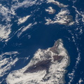
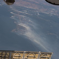
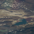
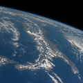
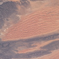
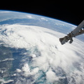
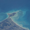
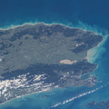
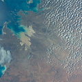
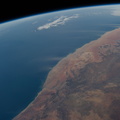
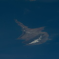
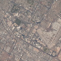
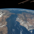
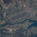
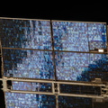
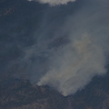
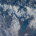
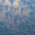
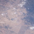
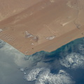
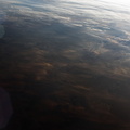
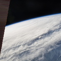
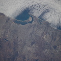
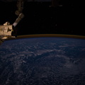
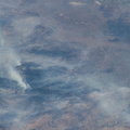
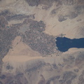
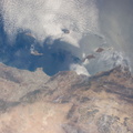
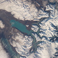
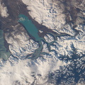
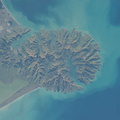
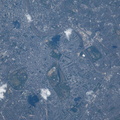
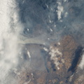
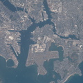
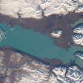
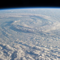
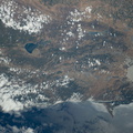
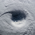
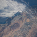
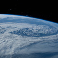
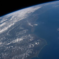
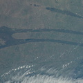
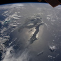
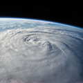
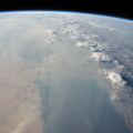
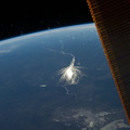
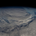
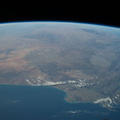
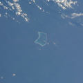
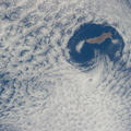
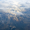
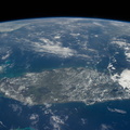
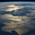
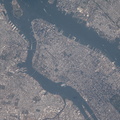
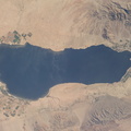
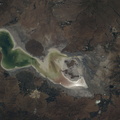
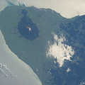
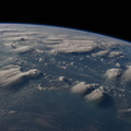
- Kulunda Steppe, Siberia in central Russia is featured in this image photographed by an Expedition 40 crew member on the International Space Station. The crew on the station called down to Houston to ask for an explanation of this strange pattern of spikes crossing the Kulunda Steppe in central Russia. The "spikes" are a prominent visual feature (center) visible from the top of the ISS orbit (approximately 52 degrees north), the highest latitude flown over by the spacecraft. In fact these linear zones are gentle folds in the surface rocks of the area, lying slightly lower than the surrounding lighter-toned agricultural lands. The dark zones are forested with pines and dotted with salt-rich lakes. The image width (left to right edge) represents more than 300 kilometers ground distance, and the forested spikes are nearly that length. The green floodplain of the famous Ob River (right) is the westernmost of Siberia's three great rivers (the others being the Yenisei and Lena). The Ob flows north (towards the top of the image) for another 2,000 kilometers to the Arctic Ocean. The city of Barnaul (population 612,000), a major center of industry, trade and culture in Siberia, lies on the banks of the river with riverboat, air and rail links to the rest of the country. A broader, winter image of the Kulunda geology and the Ob River can be seen here.
- 作成日時
- 月曜日 30 6月 2014
- アルバム
- ISS (WIP) / EXPEDITIONS / EXPEDITION 40
- Source link
- https://www.flickr.com/photos/nasa2explore/albums/72157631560566351/
- 訪問
- 64
- 評価点
- 評価なし
- この写真を評する
- License
- CC BY-NC-ND
- Modified by WikiArchives
- No (original)
- ダウンロード
- 2
EXIF メタデータ
NIKON CORPORATION NIKON D3S
- Make
- NIKON CORPORATION
- Model
- NIKON D3S
- DateTimeOriginal
- 2014:06:30 09:11:01
- ApertureFNumber
- f/11.0
Powered by Piwigo