 above sea level, is the largest high altitude lake in North America. East of the park part of the Absaroka Range can be traced by following its north to south line of snow capped peaks. Jackson Lake is southeast of Yellowstone Park, and the connected Snake River can be seen in the lower left corner. Yellowstone, established in 1872 is the world's oldest national park. It covers an area of 9,000 kilometers (3,500 square miles), lying mainly on a broad plateau of the Rocky Mountains on the Continental Divide. It's average altitude is 2,440 meters (8,000 feet) above sea level. The plateau is surrounded by mountains exceeding 3,600 meters (12,000 feet) in height. Most of the plateau was formed from once-molten lava flows, the last of which is said to have occurred 100,000 years ago. Early volcanic activity is still evident in the region by nearly 10,000 hot springs, 200 geysers and numerous vents found throughout the park.")
WIKIARCHIVES.SPACE
The Human Spaceflight Archive


Information
- Taken in
- Space
- Author
- NASA
- Description
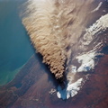
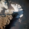
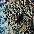
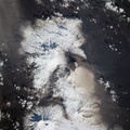
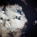
- Photographed through the Space Shuttle Endeavour's flight windows, this 70mm frame centers on Yellowstone Lake in the Yellowstone National Park. North will be at the top if picture is oriented with series of sun glinted creeks and river branches at top center. The lake, at 2,320 meters (7,732 feet) above sea level, is the largest high altitude lake in North America. East of the park part of the Absaroka Range can be traced by following its north to south line of snow capped peaks. Jackson Lake is southeast of Yellowstone Park, and the connected Snake River can be seen in the lower left corner. Yellowstone, established in 1872 is the world's oldest national park. It covers an area of 9,000 kilometers (3,500 square miles), lying mainly on a broad plateau of the Rocky Mountains on the Continental Divide. It's average altitude is 2,440 meters (8,000 feet) above sea level. The plateau is surrounded by mountains exceeding 3,600 meters (12,000 feet) in height. Most of the plateau was formed from once-molten lava flows, the last of which is said to have occurred 100,000 years ago. Early volcanic activity is still evident in the region by nearly 10,000 hot springs, 200 geysers and numerous vents found throughout the park.
- Created on
- Albums
- US SPACE PROGRAM / SPACE SHUTTLE / MISSIONS / STS-68 / Mission Photos (Edited)
- Source link
- https://www.flickr.com/photos/nasa2explore/9734163236/in/album-72157635500240228/
- Visits
- 72
- Rating score
- no rate
- Rate this photo
- License
- CC BY-NC
- Modified by WikiArchives
- No (original)
- Downloads
- 0
Powered by Piwigo