 extending from the mountain are readily seen despite partial cloud cover. The ash is mobilized with every rain in this typhoon-ridden region, flowing down valleys, filling drainage channels, and covering fields and towns. The STS-68 crew obtained excellent photographs of the region, for comparison to the radar data also obtained on the mission. Photographs in sunglint have proven particularly helpful because they show the exact outlines of surface water, which provides a datum point for the radar returns.")
WIKIARCHIVES.SPACE
The Human Spaceflight Archive


Information
- Taken in
- Space
- Author
- NASA
- Description
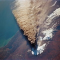
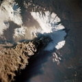
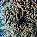
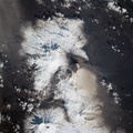
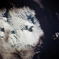
- This is a view of Mount Pinatubo, Philippine Islands, orient with the coast to the top. View westward across central Luzon and Mount Pinatubo. Manilla Bay is in partial sunglint along the left edge of the frame. The extensive flows of volcanic ash (lahars) extending from the mountain are readily seen despite partial cloud cover. The ash is mobilized with every rain in this typhoon-ridden region, flowing down valleys, filling drainage channels, and covering fields and towns. The STS-68 crew obtained excellent photographs of the region, for comparison to the radar data also obtained on the mission. Photographs in sunglint have proven particularly helpful because they show the exact outlines of surface water, which provides a datum point for the radar returns.
- Created on
- Albums
- US SPACE PROGRAM / SPACE SHUTTLE / MISSIONS / STS-68 / Mission Photos (Edited)
- Source link
- https://www.flickr.com/photos/nasa2explore/9734167278/in/album-72157635500240228/
- Visits
- 72
- Rating score
- no rate
- Rate this photo
- License
- CC BY-NC
- Modified by WikiArchives
- No (original)
- Downloads
- 0
Powered by Piwigo