 the main ship way to travel from the Atlantic to the Pacific Ocean. Also seen is a great deal of detail in Panama City (left center, on the Pacific Ocean coastline). Geologists studying the photography returned by Shuttle astronauts feel this picture is the best ever of the city. Agricultural fields can be seen on the east side of Panama City and on both sides of the Pan American Highway (the straight thin line extending to the left). Sedimentation in the Chepo River (upper left) is thought to be due to eroded soil from the agricultural lands near the sea. This river is surrounded by swamps lying along the Pacific coastline.")
WIKIARCHIVES.SPACE
The Human Spaceflight Archive


Information
- Taken in
- Space
- Author
- NASA
- Description
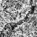
- This 70mm frame shows the Panama Canal (center, between the two dark green belts) the main ship way to travel from the Atlantic to the Pacific Ocean. Also seen is a great deal of detail in Panama City (left center, on the Pacific Ocean coastline). Geologists studying the photography returned by Shuttle astronauts feel this picture is the best ever of the city. Agricultural fields can be seen on the east side of Panama City and on both sides of the Pan American Highway (the straight thin line extending to the left). Sedimentation in the Chepo River (upper left) is thought to be due to eroded soil from the agricultural lands near the sea. This river is surrounded by swamps lying along the Pacific coastline.
- Created on
- Albums
- US SPACE PROGRAM / SPACE SHUTTLE / MISSIONS / STS-68 / Mission Photos (Edited)
- Source link
- https://www.flickr.com/photos/nasa2explore/9734165052/in/album-72157635500240228/
- Visits
- 77
- Rating score
- no rate
- Rate this photo
- License
- CC BY-NC
- Modified by WikiArchives
- No (original)
- Downloads
- 0
Powered by Piwigo