 and has no outlet. The water level varies with the amount of rainfall and evaporation in the basin. The distinct line across the center of the lake is the Lucin Cutoff. It is a 30 mile (48 kilometers), east-west causeway built in 1959 to support a rail line. The causeway connects the cities of Ogden and Lucin and affects the water level of the lake. Because the lake's main tributaries enter from the south, the water level of the southern section is several inches higher than that of the northern part. The Great Salt Lake's record high levels in the mid-1980's threatened the Lucin Cutoff, highways and sewage-treatment plants along the shore -- in 1987 pumps were installed that began draining some of the excess water into the Great Salt Lake Desert to the west. The resulting new body of water was called the Newfoundland Evaporation Basin -- it contains dissolved minerals, primarily sodium and chloride along with sulfate, magnesium, and potassium. The dissolved minerals, turbidity and microorganisms which can survive in saline water give the lake its varying colors. In this photo the north portion is dark red. The crew said that it looked like dirt when they first saw it. Crews can not remember the north portion ever looking so red -- it is usually a light blue color.")
WIKIARCHIVES.SPACE
The Human Spaceflight Archive


Information
- Taken in
- Space
- Author
- NASA
- Description
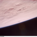
- The Great Salt is one of the most saline inland bodies of water in the world and is the largest inland body of salt water in the Western Hemisphere. The lake is fed by three rivers (Bear, Weber and Jordon) and has no outlet. The water level varies with the amount of rainfall and evaporation in the basin. The distinct line across the center of the lake is the Lucin Cutoff. It is a 30 mile (48 kilometers), east-west causeway built in 1959 to support a rail line. The causeway connects the cities of Ogden and Lucin and affects the water level of the lake. Because the lake's main tributaries enter from the south, the water level of the southern section is several inches higher than that of the northern part. The Great Salt Lake's record high levels in the mid-1980's threatened the Lucin Cutoff, highways and sewage-treatment plants along the shore -- in 1987 pumps were installed that began draining some of the excess water into the Great Salt Lake Desert to the west. The resulting new body of water was called the Newfoundland Evaporation Basin -- it contains dissolved minerals, primarily sodium and chloride along with sulfate, magnesium, and potassium. The dissolved minerals, turbidity and microorganisms which can survive in saline water give the lake its varying colors. In this photo the north portion is dark red. The crew said that it looked like dirt when they first saw it. Crews can not remember the north portion ever looking so red -- it is usually a light blue color.
- Created on
- Albums
- US SPACE PROGRAM / SPACE SHUTTLE / MISSIONS / STS-85 / Mission Photos (Edited)
- Source link
- https://www.flickr.com/photos/nasa2explore/9785916522/in/album-72157635570288026/
- Visits
- 58
- Rating score
- no rate
- Rate this photo
- License
- CC BY-NC
- Modified by WikiArchives
- No (original)
- Downloads
- 0
Powered by Piwigo