
WIKIARCHIVES.SPACE
The Human Spaceflight Archive


Information
- Taken in
- Space
- Author
- NASA
- Description
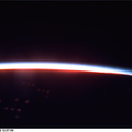
- Montreal is a city on an island that grew up around the mountain -- in 1535 Jacques Cartier landed on an island in the St. Lawrence River and named a 233 meter-high mountain Mount Royal. It was not until 1642 that Ville Marie, founded by missionaries, would officially become the city of Montreal. The cityscape contrasts well with the farmland and natural forests in this summer view. Today Montreal is the largest city in the province of Quebec, and is the second most populous metropolitan area in Canada -- in 1991 the population was just more than one million in the city and 3,127,242 in the metropolitan area. While owing its early growth to the fur trade, the city is a leading producer of aircraft, chemical and pharmaceutical products, and is a major petroleum production center. Nearly half of Canada's $5.8 billion aerospace industry is located in the Montreal area. In the image captured by the astronauts, the lighter blue, wide river is the St. Lawrence. The city of Montreal is located on the Ile de Montreal to the northwest of the St. Lawrence river. The Ottawa River enters the St. Lawrence near the center of the view. Mirabel International Airport stands out well, on the north side of the city. The long, narrow strips of land in the image are indicative of French agricultural land use. The narrow ends of farmlands are oriented perpendicular to rivers so that more farmers will have access to water resources.
- Created on
- Albums
- US SPACE PROGRAM / SPACE SHUTTLE / MISSIONS / STS-85 / Mission Photos (Edited)
- Source link
- https://www.flickr.com/photos/nasa2explore/9786120304/in/album-72157635570288026/
- Visits
- 67
- Rating score
- no rate
- Rate this photo
- License
- CC BY-NC
- Modified by WikiArchives
- No (original)
- Downloads
- 0
Powered by Piwigo