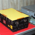
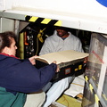
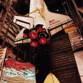
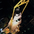
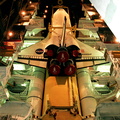
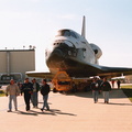
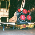
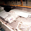
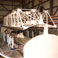
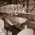
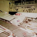
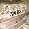
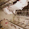
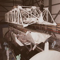
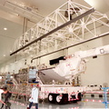
, is stored in the payload bay of the orbiter Endeavour before door closure. SRTM is the primary payload on mission STS-99, scheduled to launch Sept. 16 at 8:47 a.m. EDT from Launch Pad 39A. A specially modified radar system, the SRTM will gather data for the most accurate and complete topographic map of the Earth's surface that has ever been assembled. SRTM will make use of radar interferometry, wherein two radar images are taken from slightly different locations. Differences between these images allow for the calculation of surface elevation, or change. The SRTM hardware consists of one radar antenna in the shuttle payload bay and a second radar antenna attached to the end of a mast extended 60 meters (195 feet) out from the shuttle. SRTM is an international project spearheaded by the National Imagery and Mapping Agency and NASA, with participation of the German Aerospace Center DLR.")
WIKIARCHIVES.SPACE
The Human Spaceflight Archive


Information
- Taken in
- Kennedy Space Center
- Auteur
- NASA
- Description
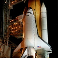
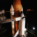
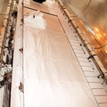
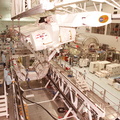
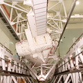
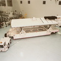
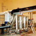
- In the Orbiter Processing Facility, a radar antenna, part of the Shuttle Radar Topography Mission (SRTM), is stored in the payload bay of the orbiter Endeavour before door closure. SRTM is the primary payload on mission STS-99, scheduled to launch Sept. 16 at 8:47 a.m. EDT from Launch Pad 39A. A specially modified radar system, the SRTM will gather data for the most accurate and complete topographic map of the Earth's surface that has ever been assembled. SRTM will make use of radar interferometry, wherein two radar images are taken from slightly different locations. Differences between these images allow for the calculation of surface elevation, or change. The SRTM hardware consists of one radar antenna in the shuttle payload bay and a second radar antenna attached to the end of a mast extended 60 meters (195 feet) out from the shuttle. SRTM is an international project spearheaded by the National Imagery and Mapping Agency and NASA, with participation of the German Aerospace Center DLR.
- Erstallt den
- Donneschten 5 August 1999
- Albumen
-
Locations / OSM-4.915832801313164
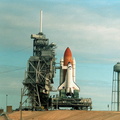
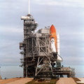
US SPACE PROGRAM / SPACE SHUTTLE / MISSIONS / STS-99 / Rocket preparation
- Source link
- https://science.ksc.nasa.gov/gallery/photos/1999/
- Visitten
- 70
- Bewäertungs-Stand
- nach keng Bewäertung
- Foto bewäerten
- License
- CC BY-NC-ND
- Modified by WikiArchives
- No (original)
- Downloads
- 0
Ennerstetzt vun Piwigo