. EREP was designed to explore the use of the widest possible portion of the electromagnetic spectrum for Earth resource investigations with sensors that recorded data in the visible, infrared, and microwave spectral regions. Resources subject to this study included a capability of mapping Earth resources and land uses, crop and forestry cover, health of vegetation, types of soil, water storage in snow pack, surface or near-surface mineral deposits, sea surface temperature, and the location of likely feeding areas for fish, etc. A significant feature of EREP was the ability of man to operate the sensors in a laboratory fashion.")
WIKIARCHIVES.SPACE
The Human Spaceflight Archive
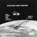
This concept illustrates Skylab Earth observation studies, an Earth Resources Experiment Package (EREP). EREP was designed to explore the use of the widest possible portion of the electromagnetic spectrum for Earth resource investigations with sensors that recorded data in the visible, infrared, and microwave spectral regions. Resources subject to this study included a capability of mapping Earth resources and land uses, crop and forestry cover, health of vegetation, types of soil, water storage in snow pack, surface or near-surface mineral deposits, sea surface temperature, and the location of likely feeding areas for fish, etc. A significant feature of EREP was the ability of man to operate the sensors in a laboratory fashion.


Information
- Taken in
- Other
- بواسطة :
- NASA
- الوصف
-
This concept illustrates Skylab Earth observation studies, an Earth Resources Experiment Package (EREP). EREP was designed to explore the use of the widest possible portion of the electromagnetic spectrum for Earth resource investigations with sensors that recorded data in the visible, infrared, and microwave spectral regions. Resources subject to this study included a capability of mapping Earth resources and land uses, crop and forestry cover, health of vegetation, types of soil, water storage in snow pack, surface or near-surface mineral deposits, sea surface temperature, and the location of likely feeding areas for fish, etc. A significant feature of EREP was the ability of man to operate the sensors in a laboratory fashion.
- Created on
- الألبومات
- US SPACE PROGRAM / SKYLAB / DIAGRAMS
- Source link
- https://images.nasa.gov/search-results?q=skylab&page=3&media=image&yearStart=1920&yearEnd=2023
- الزوار
- 76
- حسب معدل التقييم
- كن أول من يعطي تقيمه لهذه الصورة
- قيم هذه الصورة
- License
- Public Domain
- Modified by WikiArchives
- No (original)
- تنزيل
- 0
بدعم من Piwigo