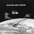
 as opposed to that imagery which will be available from a 50-degree inclined orbit. The region between the two broken lines will be in the area that can be covered by Skylab A photographic facilities in the 1972-73 time period.")
WIKIARCHIVES.SPACE
The Human Spaceflight Archive


Information
- Taken in
- Other
- Szerző
- NASA
- Leírás
- This map of Europe has been marked to indicate areas of photographic imagery available from Apollo photography (32-degree orbits) as opposed to that imagery which will be available from a 50-degree inclined orbit. The region between the two broken lines will be in the area that can be covered by Skylab A photographic facilities in the 1972-73 time period.
- Created on
- Albumok
- US SPACE PROGRAM / SKYLAB / DIAGRAMS
- Source link
- https://www.flickr.com/photos/nasa2explore/albums/72157634791373199
- Látogatás
- 129
- Átlagos pontszám
- még nincs értékelve
- Értékelje a képet
- License
- CC BY-NC
- Modified by WikiArchives
- No (original)
- Letöltés
- 0
Az oldal motorja: Piwigo