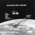
 as opposed to that imagery which will be available from a 50-degree inclined orbit. The region between the two broken lines will be in the area that can be covered by the first manned Skylab mission in 1973.")
WIKIARCHIVES.SPACE
The Human Spaceflight Archive


Information
- Taken in
- Other
- Autor
- NASA
- Descrición
- This map of South America has been marked to indicate areas of photographic imagery available from Apollo photography (32-degree orbits) as opposed to that imagery which will be available from a 50-degree inclined orbit. The region between the two broken lines will be in the area that can be covered by the first manned Skylab mission in 1973.
- Created on
- Álbums
- US SPACE PROGRAM / SKYLAB / DIAGRAMS
- Source link
- https://www.flickr.com/photos/nasa2explore/albums/72157634791373199
- Visitas
- 124
- Valoración
- non valorada
- Valora esta foto
- License
- CC BY-NC
- Modified by WikiArchives
- No (original)
- Descargas
- 0
Desenvolvido por Piwigo