WIKIARCHIVES.SPACE
The Human Spaceflight Archive

Information
- Taken in
- Space
- Penulis
- NASA
- Description
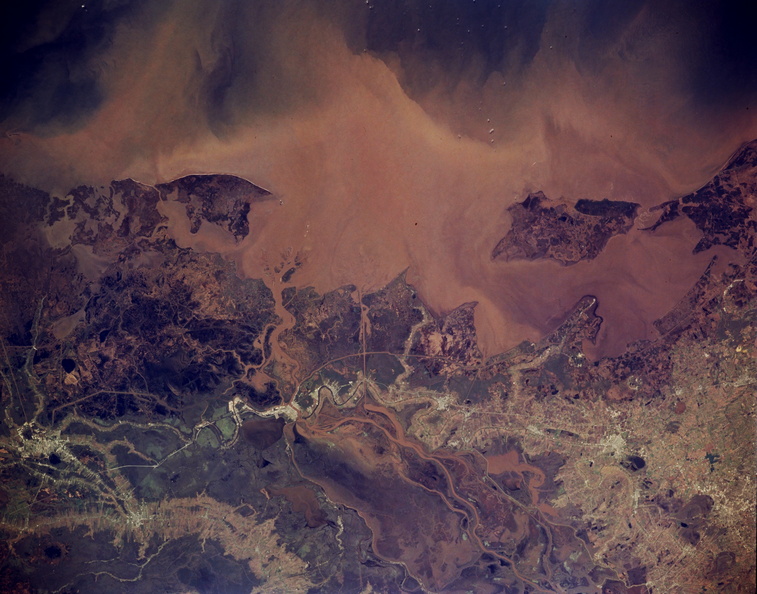
- This dramatic photograph shows a complicated pattern of streams and canals that is typical of this sensitive wetland environment. Despite the large quantity of silt that is regularly deposited in the Atchafalaya River delta, this section of the Louisiana coast is experiencing an alarming loss of shoreline through natural erosion. U.S. Highway 90 can be traced from Houma in the east (lower left edge) through Morgan City, Franklin, Jeanerette, New Iberia, and Lafayette (right margin of the photograph). Discernible are large Marsh Island and several bays from west to east—Vermilion Bay, West Cote Blanche Bay, East Cote Blanche Bay, and Atchafalaya Bay.
- Created on
- Album
- US SPACE PROGRAM / SPACE SHUTTLE / MISSIONS / STS-62 / Mission Photos (Edited)
- Source link
- https://www.flickr.com/photos/nasa2explore/9367948234/in/album-72157634790274619/
- Kunjungi
- 39
- Skor peringkat
- tidak diperingkat
- Peringkatkan foto ini
- License
- CC BY-NC
- Modified by WikiArchives
- No (original)
- Downloads
- 0
Didukung oleh Piwigo


