. Nadir coordinates are 37.17 degrees south latitude and 16.7 degrees west longitude.")
WIKIARCHIVES.SPACE
The Human Spaceflight Archive


Information
- Taken in
- Space
- Fotograf
- NASA
- Beskrivning
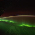
- One of the Expedition 29 crew members aboard the International Space Station, flying at an altitude of approximately 220 miles, took this picture over the South Atlantic Ocean, showing airglow, a number of stars and moon glint (on lower left side of image). Nadir coordinates are 37.17 degrees south latitude and 16.7 degrees west longitude.
- Skapad den
- Fredag 16 September 2011
- Album
- ISS (WIP) / EXPEDITIONS / EXPEDITION 29
- Source link
- https://www.flickr.com/photos/nasa2explore/albums/72157627462367306
- Besök
- 21
- Röstpoäng
- inget betyg
- Betygsätt den här bilden
- License
- CC BY-NC-ND
- Modified by WikiArchives
- No (original)
- Nerladdningar
- 0
EXIF Metadata
NIKON CORPORATION NIKON D3S
- Make
- NIKON CORPORATION
- Model
- NIKON D3S
- DateTimeOriginal
- 2011:09:16 03:13:21
- ApertureFNumber
- f/2.8
Baserat på Piwigo