WIKIARCHIVES.SPACE
The Human Spaceflight Archive

Information
- Taken in
- Space
- 作者
- NASA
- 描述
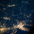
- Man-made archipelagos near Dubai, United Arab Emirates, are featured in this image photographed by an Expedition 37 crew member on the International Space Station, flying at approximately 220 miles above Earth. The municipality of Dubai is the largest city of the Persian Gulf emirate of the same name, and has built a global reputation for large-scale developments and architectural works. Among the most visible of these developments -- particularly from the perspective of astronauts onboard the space station -- are three man-made archipelagos. The two Palm Islands -- Palm Jumeirah (right) and Palm Jebel Ali (out of frame further to the right) -- appear as stylized palm trees when viewed from above. The World Islands (center frame) evoke a rough map of the world from an air- or space-borne perspective. The Palm Jumeirah project began in 2001 and required more than 50 million cubic meters of dredged sand to raise the islands above the Persian Gulf sea level. Construction of the Palm Jumeirah islands was completed in 2006; for several years now they have been developed for residential and commercial housing and infrastructure. Creation of the World Islands was begun in 2003 and completed in 2008, using 320 million cubic meters of sand and 37 million tons of rock for the surrounding 27 kilometer-long protective breakwater.
- 创建于
- 星期一 14 十月 2013
- 相册
- ISS (WIP) / EXPEDITIONS / EXPEDITION 37
- Source link
- https://www.flickr.com/photos/nasa2explore/albums/72157631323322922
- 访问量
- 21
- 评价得分
- 没有评分
- 评分
- License
- CC BY-NC-ND
- Modified by WikiArchives
- No (original)
- 下载
- 0
EXIF 元数据
NIKON CORPORATION NIKON D3S
- Make
- NIKON CORPORATION
- Model
- NIKON D3S
- DateTimeOriginal
- 2013:10:14 12:01:53
- ApertureFNumber
- f/14.0
技术支持 Piwigo


