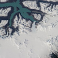
. Le Havre is the largest container port in France, and the second largest in terms of total traffic after Marseille. The extensive port facilities, visible at center, include numerous docks (large cargo ships are clearly visible in this detailed photograph), storage tanks for petro- and other chemicals, and large industrial and warehouse facilities with white rooftops. The port also serves seagoing pleasure cruise vessels. The southern edge of the port facility along the Seine includes a seawall-enclosed ship turning area (lower center). The Montgeon Forest, visible as a large green region at upper center, includes 200 hectares of woodland and 30 hectares of meadows and lawns. The urban area of Le Havre, to the north of the port facilities, was largely destroyed during World War II. After the war, the city was rebuilt following the vision of architect Auguste Perret. Perret favored the use of reinforced and precast concrete in building structures, and much of the city built between 1945 and 1964 follows his plan in both form and materials – leading to the designation of Le Havre as a UNESCO World Heritage Site.")
WIKIARCHIVES.SPACE
The Human Spaceflight Archive


Information
- Taken in
- Space
- 作成者
- NASA
- 説明
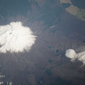
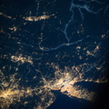
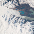
- Le Havre, France is featured in this image photographed by an Expedition 37 crew member on the International Space Station. The port city of Le Havre, France is located at the confluence of the Seine River and the English Channel along the northern coastline of the country (Upper Normandy region). Le Havre is the largest container port in France, and the second largest in terms of total traffic after Marseille. The extensive port facilities, visible at center, include numerous docks (large cargo ships are clearly visible in this detailed photograph), storage tanks for petro- and other chemicals, and large industrial and warehouse facilities with white rooftops. The port also serves seagoing pleasure cruise vessels. The southern edge of the port facility along the Seine includes a seawall-enclosed ship turning area (lower center). The Montgeon Forest, visible as a large green region at upper center, includes 200 hectares of woodland and 30 hectares of meadows and lawns. The urban area of Le Havre, to the north of the port facilities, was largely destroyed during World War II. After the war, the city was rebuilt following the vision of architect Auguste Perret. Perret favored the use of reinforced and precast concrete in building structures, and much of the city built between 1945 and 1964 follows his plan in both form and materials – leading to the designation of Le Havre as a UNESCO World Heritage Site.
- 作成日時
- 土曜日 26 10月 2013
- アルバム
- ISS (WIP) / EXPEDITIONS / EXPEDITION 37
- Source link
- https://www.flickr.com/photos/nasa2explore/albums/72157631323322922
- 訪問
- 25
- 評価点
- 評価なし
- この写真を評する
- License
- CC BY-NC-ND
- Modified by WikiArchives
- No (original)
- ダウンロード
- 0
EXIF メタデータ
NIKON CORPORATION NIKON D3X
- Make
- NIKON CORPORATION
- Model
- NIKON D3X
- DateTimeOriginal
- 2013:10:26 13:35:49
- ApertureFNumber
- f/6.7
Powered by Piwigo