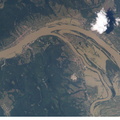
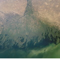
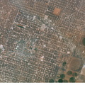
. The photographs show flooding around the Danube Bend area just north of Budapest near the city of Vác, Hungary. The flood peaked in Budapest the day after this photo was made, on August 19, at about 8.5 meters (28 feet), exceeding the previous 1965 flood record. This image shows the waters inundating farmland in the flood plain. Image no. ISS005-E-10926 shows the area four days later.")
WIKIARCHIVES.SPACE
The Human Spaceflight Archive


Information
- Taken in
- Space
- Автор
- NASA
- Описание
- This is the first of two images recently released by the Earth Sciences and Image Analysis Laboratory at Johnson Space Center, showing the devastating European flooding in August. The images were captured by astronauts using a digital still camera onboard the International Space Station (ISS). The photographs show flooding around the Danube Bend area just north of Budapest near the city of Vác, Hungary. The flood peaked in Budapest the day after this photo was made, on August 19, at about 8.5 meters (28 feet), exceeding the previous 1965 flood record. This image shows the waters inundating farmland in the flood plain. Image no. ISS005-E-10926 shows the area four days later.
- Създаден на
- неделя 18 август 2002
- Албуми
- ISS (WIP) / EXPEDITIONS / EXPEDITION 05
- Source link
- https://www.flickr.com/photos/nasa2explore/albums/72157635065835713
- Посещения
- 56
- Рейтинг
- няма оценка
- Оцени тази снимка
- License
- CC BY-NC-ND
- Modified by WikiArchives
- No (original)
- Сваляния
- 0
Осъществено от Piwigo