
WIKIARCHIVES.SPACE
The Human Spaceflight Archive


Information
- Taken in
- Edwards Air Force Base
- Автор
- NASA
- Опис
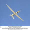
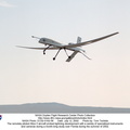
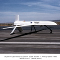
- The snow-capped peak of Mt. San Antonio in the San Gabriel range is visible as the remotely piloted Altus II flies over Southern California’s high desert.
- Дата зйомки
- Понеділок 29 Червень 1998
- Альбоми
- US SPACE PROGRAM / AERONAUTICS RESEARCH / Altus
- Source link
- https://www.dfrc.nasa.gov/Gallery/Photo/Altus/index.html
- Відвідувань
- 29
- Рейтинговий бал
- не оцінено
- Оцінити цю фотографію
- License
- Public Domain
- Modified by WikiArchives
- No (original)
- Завантаження
- 0
Підтримка Piwigo