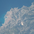
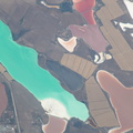
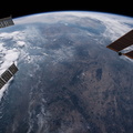
. The St. Mary's River leads into Lake Superior heading west and Lake Huron heading south.")
WIKIARCHIVES.SPACE
The Human Spaceflight Archive


Information
- Taken in
- Space
- 擁有者
- NASA
- 描述
- Canada and the United States are separated at this entry point by the St. Mary's River. The similarly named cities of Sault Ste. Marie, Michigan is to the south and Sault Ste. Marie, Ontario is to the north (in this orientation they are from left to right). The St. Mary's River leads into Lake Superior heading west and Lake Huron heading south.
- 建立於
- 星期三 20 六月 2018
- 相冊
- ISS (WIP) / EXPEDITIONS / EXPEDITION 56
- Source link
- https://www.flickr.com/photos/nasa2explore/albums/72157681794432804
- 訪問
- 17
- 評價得分
- 沒有評價
- 對圖片投票
- License
- CC BY-NC-ND
- Modified by WikiArchives
- No (original)
- 下載
- 2
EXIF 元數據
NIKON CORPORATION NIKON D5
- Make
- NIKON CORPORATION
- Model
- NIKON D5
- DateTimeOriginal
- 2018:06:20 16:27:20
- ApertureFNumber
- f/10.0
Powered by Piwigo