WIKIARCHIVES.SPACE
The Human Spaceflight Archive

Information
- Taken in
- Space
- Autor
- NASA
- Kirjeldus
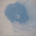
- This oblique view from 255 miles above northwest Africa, looking from north to south, shows the "Eye of Sahara" in Mauritania. The circular geologic feature, also known as the Richat Structure, is thought to be caused by an uplifted dome—geologists would classify it as a domed anticline—that has been eroded to expose the originally flat rock layers.
- Loodud
- Pühapäev 21 Aprill 2019
- Albumid
- ISS (WIP) / EXPEDITIONS / EXPEDITION 59
- Source link
- https://www.flickr.com/photos/nasa2explore/albums/72157684823968065
- Külastust
- 27
- Hinnanguskoor
- hindamata
- Hinda seda fotot
- License
- CC BY-NC-ND
- Modified by WikiArchives
- No (original)
- Allalaadimised
- 1
EXIF metaandmed
NIKON CORPORATION NIKON D5
- Make
- NIKON CORPORATION
- Model
- NIKON D5
- DateTimeOriginal
- 2019:04:21 15:50:11
- ApertureFNumber
- f/16.0
Toob teieni Piwigo


